A massive amount of snow fell in the mountains over the winter and into spring. You know that. But what is striking about this year’s snowpack is its persistence. We can’t emphasize enough how dangerous early season travel in the mountains might be this year.
Cornices are hanging over the PCT, posing a risk to those who pass them. Avalanches continue. Falls are a real risk. Route finding and hypothermia are concerns. Rivers and creeks are in flood and drowning is one of the most common causes of death for backpackers.
Every spring, I talk to hundreds of excited day hikers, section hikers, thru-hikers and horseback riders who are eager to play in the mountains. Come Memorial Day, we’re ready. By June, we’re chomping at the bit, feeling that it’s time for summer in the mountains. Is it really? Hardly. It’s normal that snow persists throughout June in most western mountains. Historically, that’s been the case. We may have forgotten that after several years of drought and corresponding low snow packs. Yet even by historic standards, this year is not normal. The snow coverage is truly extensive.
Often, early season northbound thru-hikers reach the southern Sierra only to find that there is too much snow and creeks are raging and dangerous to cross. A few of them with the skills and confidence for extended snow travel soldier on. But many people don’t have the background, fitness, equipment, knowledge, or risk tolerance for hundreds of miles of snow travel. Be honest with yourselves. Most backpackers should indeed wait for the snow to melt and dry trails to emerge.
There will still be plenty of snow in mid-July this. So, where can you hike on the PCT in June? Not a lot of places. The PCT travels high ridges, peaks and passes pretty much all the way to Canada. It’s often hugging the snowiest slopes. Early in the hiking season you’ll find only a few short stretches of snow-free trail in the high country.
Maps that show the snow along the PCT
They’re not super high resolution. We apologize for that. You might need to squint to see some of the snow along the PCT. Know that sometimes snow lingers under tree cover and might not be visible. If you’d like another view, click on the “snow depth” button on our interactive map.
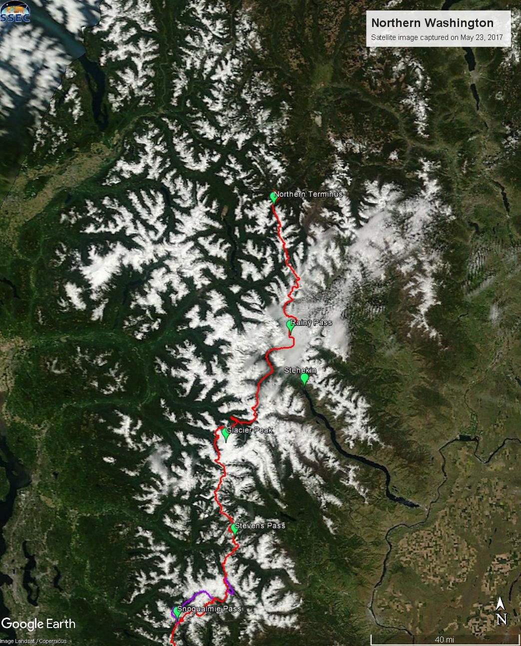
Satellite image of Northern Washington on a mostly clear day. You can see some clouds in the North Cascades. May 23, 2017.
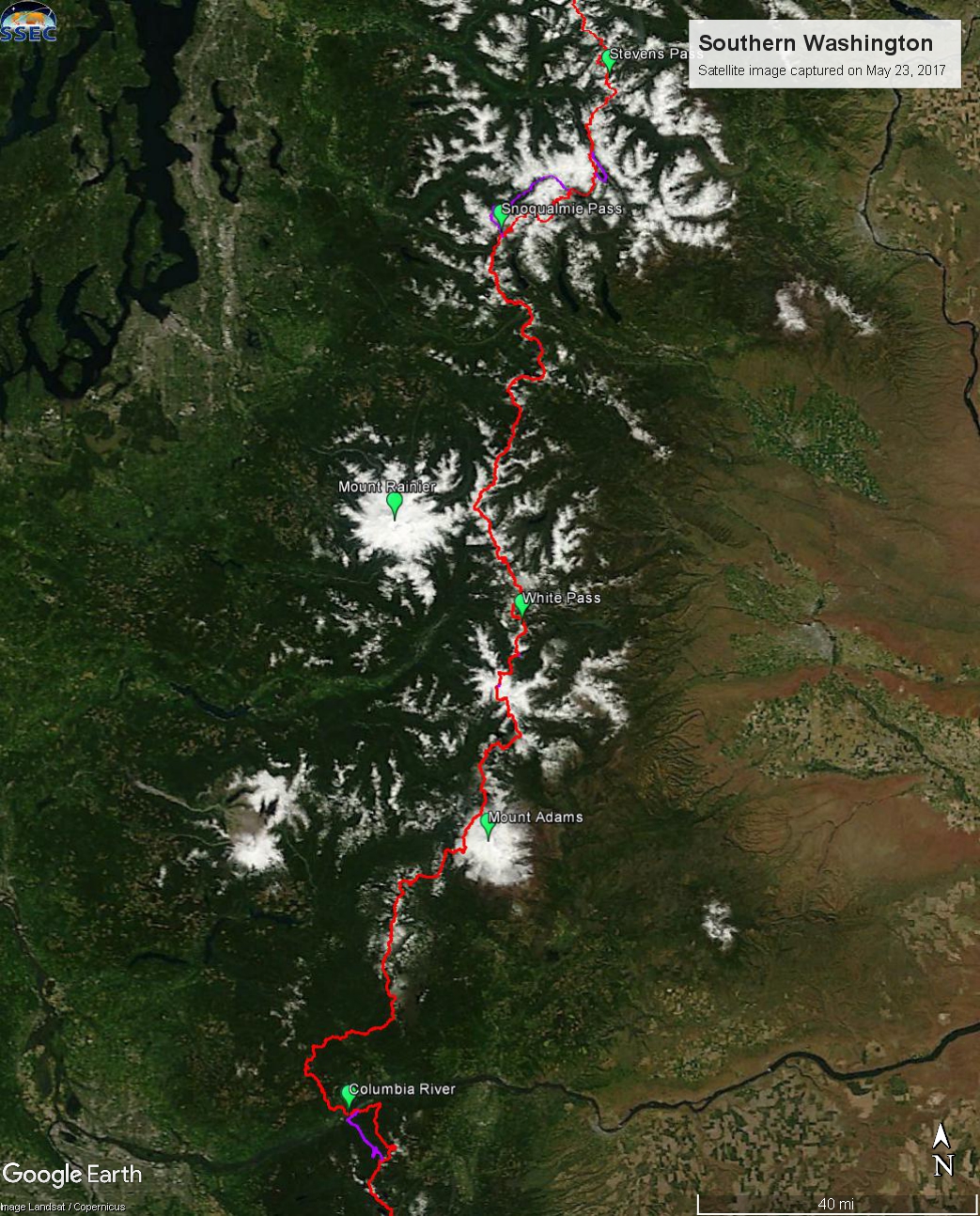
Satellite image of Southern Washington on a clear day. May 23, 2017.

Satellite image of Northern Oregon on a clear day. May 23, 2017.
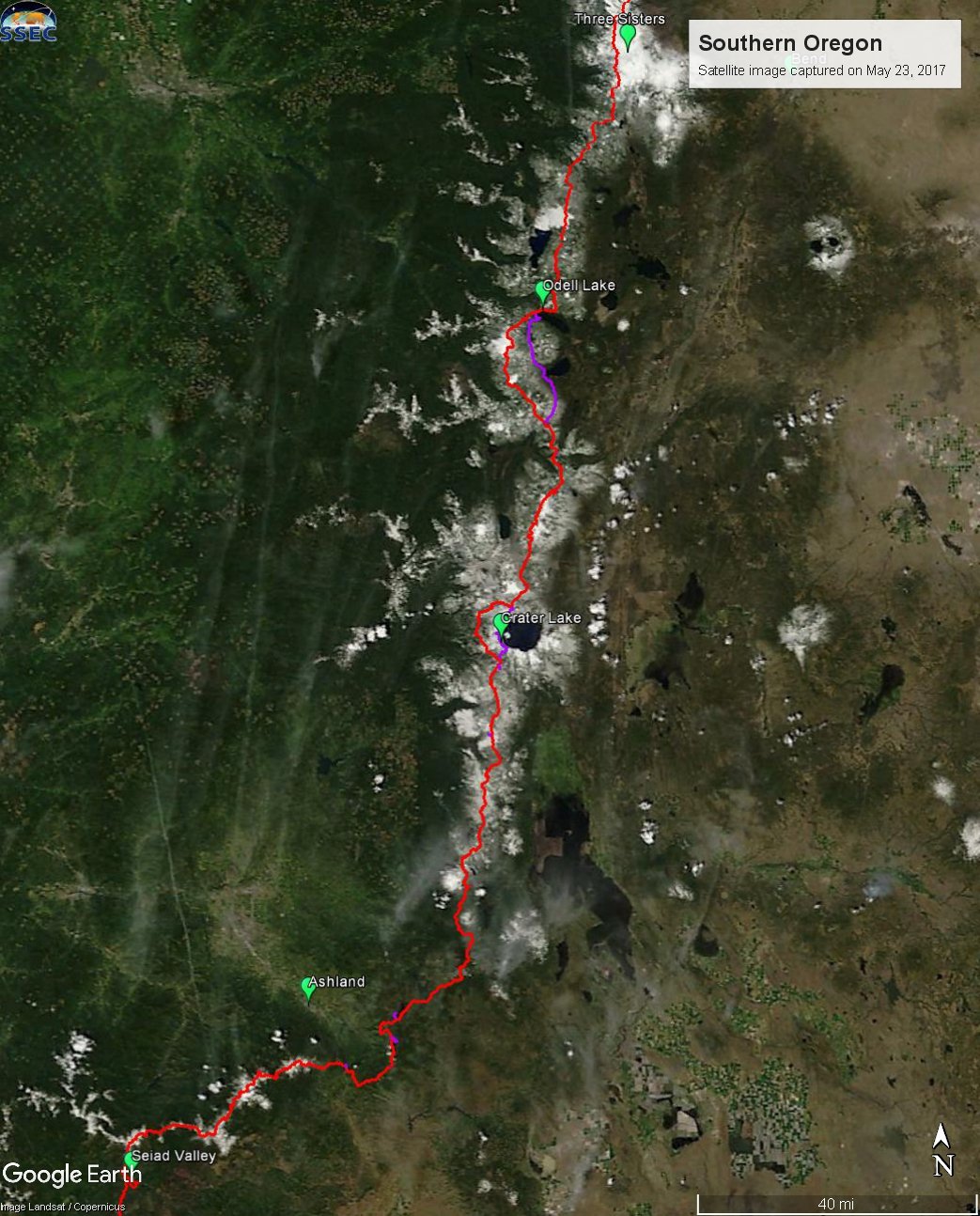
Satellite image of Southern Oregon on a clear day. May 23, 2017.

Satellite image of Northern California on a clear day. May 23, 2017.
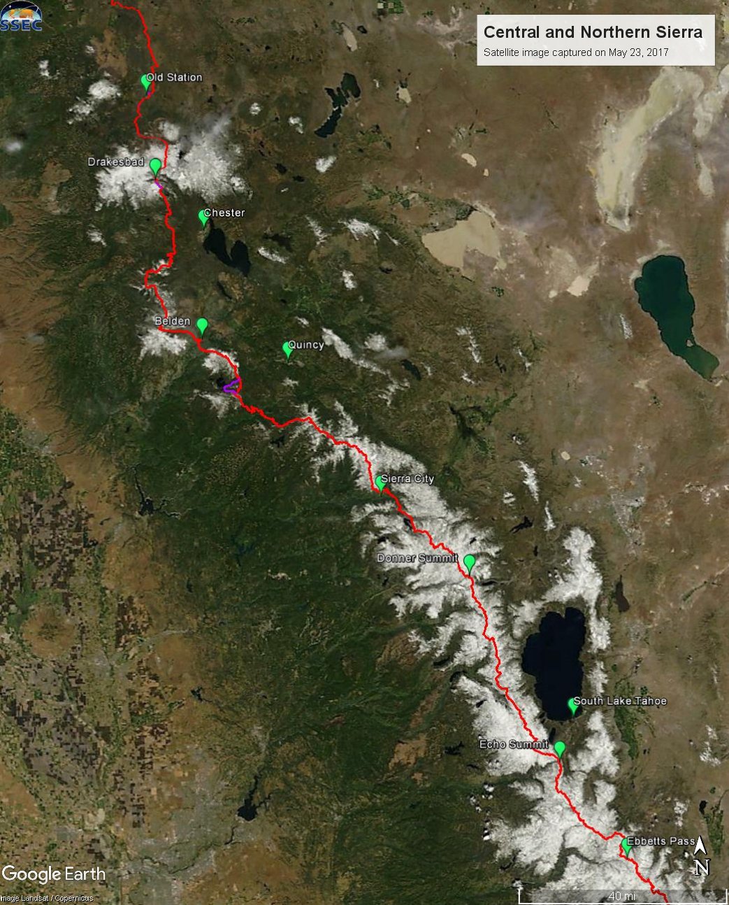
Satellite image of the Central and Northern Sierra on a clear day. May 23, 2017.
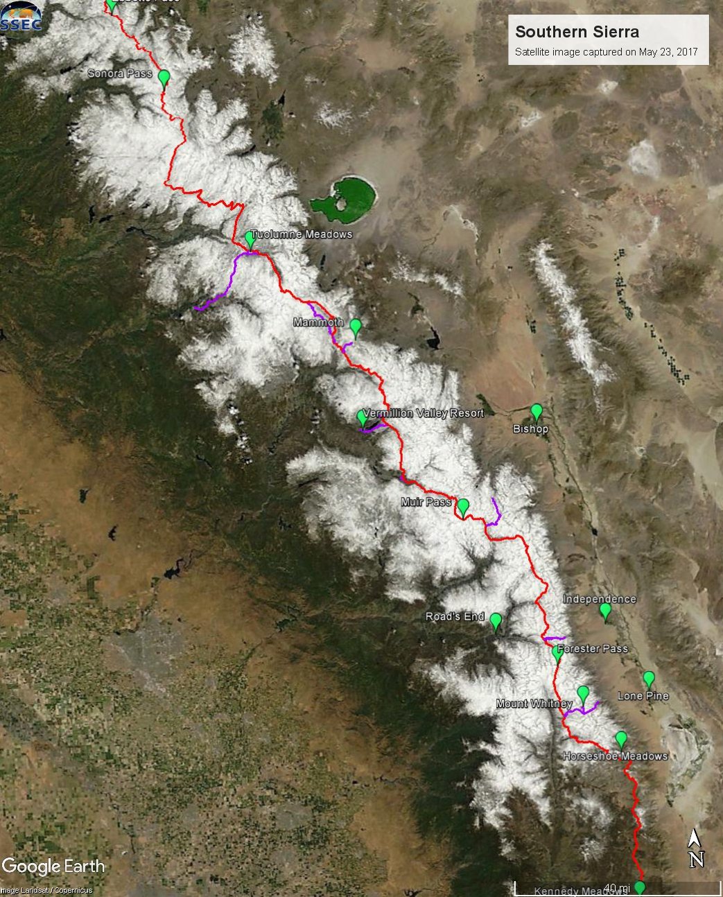
Satellite image of the Southern Sierra on a clear day. May 23, 2017.
The most substantial snow free sections of the PCT in May and June
There isn’t a lot of dry trail. As we said, the mountains have snow.
- Southern California; you’ve got 700 miles of dry trail down south. Heads up that the lower elevations can be dangerously, and inappropriately, hot at this time of year.
- The Hat Creek Rim north of Old Station, California; this is one of the longest dry stretches of trail at this time of year and it’s the perfect season to hike this area.
- Southbound from Dunsmuir, California; but not all the way to Burney Falls as snow persists at high elevation.
- Southbound from Seiad Valley, California; but not far up into the Marble Mountains as they have snow. This is a short area and mostly a road walk, so not the most desirable destination to travel a long way for.
- Around Ashland and Cascade Siskiyou National Monument; this is a beautiful area in the Spring for short trips.
- Around Timothy Lake south of Mount Hood; it probably still has some snow at the time we’re writing, but it’s one of the first sections of Oregon the melt out.
- The Columbia River Gorge: there’s some really beautiful snow free hiking near the Bridge of the Gods, but as you gain elevation, you’ll quickly hit snow. It’s far too early for Mount Hood for instance.
So, what should you do?
Snow will persist this summer. Be prepared, or wait for it to melt.
Thru-hiking is hard. It always is. I’m of the school of mind that it’s best to delay entry into the Sierra until substantial snow has melted. If you’re entering early, expect that you’ll have pretty extensive snow travel and raging creeks until at least Tahoe and perhaps beyond. If you’re delaying entry until later in June, know that you’ll still have snow travel, but much less of it. If you find yourself in Northern California, and August is creeping by, consider flipping to the northern terminus and going southbound. You’ll likely gain a few weeks of fall hiking weather with that strategy. I would not however, flip to Northern California or Oregon in June. Look at the maps. It’s covered in snow. In places, that snow is even harder than the High Sierra.
Section hikers might just want to wait, or seek lower elevation hikes. If you’re chomping at the bit to head on out, tackle one of the places we mentioned above. Or perhaps go somewhere that’s not the PCT. There are lots of beautiful places to hike well off the crest.
Southbounders: we don’t really know. Head on over to our southbounder’s guide for a sobering discussion of the challenges you face. Steep, dangerous snow will persist well into July this year. Be truly prepared, or don’t go.
If you’re going anyways
I’m worried for my fellow backpackers. Already this year, too many people have died falling on snow or drowning in creeks along the PCT corridor. In challenging years like this, incidents are far too common. I talk to locals, old timers, park rangers, sheriff’s offices and search and rescue people about it. We’re worried for your safety. Don’t take unacceptable risks. Be prepared, or don’t go.
Some of you are well prepared. Good for you. Have the time of your life. Be safe and cautious. Don’t underestimate the risk. For the rest? The trail will be here forever. Come hike it when the conditions are right for you. For most backpackers, that means dry trail.
For more from me check out:
- A big snow is one to remember (PDF); magazine article I wrote reflecting back on our last big snow year
- Lost, stranded, injured and sick on the PCT (PDF); magazine article I wrote about risk and incidents on the trail
- Our general safety advice, especially our information about search and rescue, trip plans and beacons and our snow information
- Part 1 and Part 2 of a series about the snow situation and the effect on thru-hikers on the Hyperlite Mountain Gear blog.
- This Year’s Epic Snowpack Could Pose a Threat to 2017 Pacific Crest Trail Hikers; interview I did about the snow situation with Backpacker Magazine